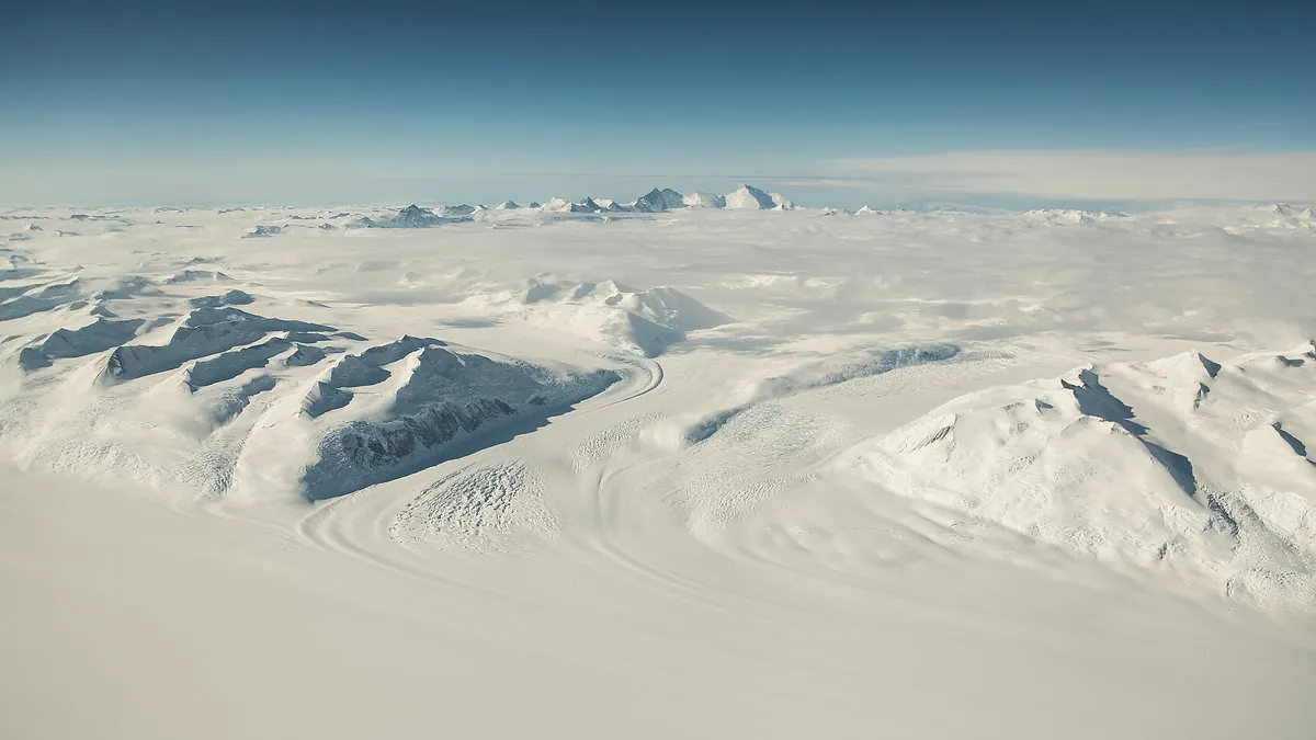
A vast ancient landscape, untouched for more than 34 million years, has been discovered buried beneath more than a mile of ice in East Antarctica.
Scientists have uncovered a dramatic ancient landscape buried beneath Antarctica’s thick ice sheet, revealing towering ridges and deep valleys frozen in place for millions of years.
Scientists refer to this as a ‘cold-based’ ice sheet, meaning the ice is frozen to the ground and causes minimal erosion.
Roughly 14 million years ago, the expanding East Antarctic Ice Sheet engulfed the area in ice.
Although surrounding ice may have partially melted during these warm spells, it was never enough to expose the ancient terrain.
In East Antarctica, a vast ancient landscape that has been buried under more than a mile of ice for over 34 million years has been found.
Deep inland and far from the coast, in a remote area of East Antarctica about the size of Belgium, is where the hidden terrain is found. It is called Wilkes Land.
This ice-enclosed ancient world had rivers, forests, and possibly even palm trees, according to scientists who used satellite data and ice-penetrating radar.
Actually, palm tree pollen has been discovered on the adjacent Antarctic coast in the past, offering compelling proof of a once-luxuriant habitat.
The buried landscape is thought to cover more than 12,000 square miles, or roughly the area of Maryland, according to researchers.
The study’s lead author, Professor Stewart Jamieson of Durham University, described it as “like unearthing a time capsule.”.
As the continents slowly moved over tens of millions of years ago, Antarctica moved in the direction of the South Pole.
This movement isolated the continent from warmer waters by forming a strong ocean current around it. The planet cooled as atmospheric carbon dioxide levels decreased at the same time.
When taken as a whole, these modifications caused enormous ice sheets to form, turning Antarctica into the frozen desert it is today.
The study’s lead author, Stewart Jamieson, a geography professor at Durham University, stated that the land beneath the East Antarctic ice sheet is not as well-known as the surface of Mars.
Professor Jamieson stated, “We’re looking more closely at a small portion of that landscape to see what it can tell us about the evolution of the landscape and the evolution of the ice sheet.”.
Beneath the thick layer of Antarctic ice, scientists have discovered a striking ancient landscape that includes deep valleys and towering ridges that have been frozen for millions of years.
According to the study, there are three enormous blocks of elevated land that are 75–105 miles long and up to 53 miles wide. They are divided by valleys that are up to 25 miles wide and nearly 3,900 feet deep.
In contrast to many glaciers that churn the ground beneath them, the ice in this region of East Antarctica is very cold and moves very slowly—less than 16 feet annually.
The landscape is remarkably detailed thanks to this slow movement. This type of ice sheet is known to scientists as “cold-based” because it is frozen to the ground and doesn’t erode much.
Neil Ross, a co-author of the study and a professor of environmental geophysics at Newcastle University, said, “It is amazing that this landscape, which has been hidden in plain sight for many years, can tell us so much about the early and long-term history of the East Antarctic ice sheet.”.
It also aids in our comprehension of how it might change in reaction to upcoming climate change. “…
Researchers employed computer models to track the changes in the landscape over time and satellite imagery to identify minute surface irregularities.
Due to the sheer weight of the ice covering them, some parts of the buried terrain have gradually risen by up to 1,600 feet.
The untouched landscape provides a unique glimpse into Antarctica’s distant history, before the continent was engulfed by ice.
Professor Jamieson explained, “What we find is an ancient land surface that has not been eroded by the ice sheet, and instead it looks like it was created by rivers before the ice came along.”.
In the past, the area probably had tumbling rivers and thick forests, flourishing in a mild climate.
The high ground was probably divided into separate blocks prior to the arrival of the first glaciers by the deep fissures and cracks caused by the ancient supercontinent Gondwana’s disintegration.
Little glaciers formed as the climate cooled over time, gradually deepening the valleys and forming the landscape into the iconic U-shaped formations that are characteristic of mountain glaciation.
Around 14 million years ago, the region was covered in ice due to the East Antarctic Ice Sheet’s expansion.
The area stayed frozen even during later warm periods, like the mid-Pliocene, which occurred about 3 million years ago.
It’s possible that some of the surrounding ice melted during these warm spells, but not enough to reveal the ancient landscape.
This finding is crucial now because Earth is getting close to temperatures and carbon dioxide levels not seen since those ice-free days.
Though it would take a lot of time, money, and effort to drill through more than a mile of solid ice to reach this lost landscape, scientists warn that if global warming persists, portions of the ice sheet may eventually retreat once more.
“In order to comprehend how the ice sheet and its underlying landscape have changed over their lengthy history, we’ll keep investigating the landscape, trying our best to fill in the gaps where surveys don’t exist,” Professor Jamieson stated. “…


